You can find this route on the BikeSquare app with code GTL 18
ANGUILLARA / ROME THE VIA FRANCIGENA AND THE VEIO PARK
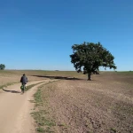
The last stage of the GTL (or the first, if you decide to leave northwards: it is not one-way!) largely exploits the route of the Via Francigena, in the last stretch of the long journey of the pilgrims who arrived in the Holy City. From Anguillara we pass through roads with little traffic near Lake Martignano – depending on the season, it will be more or less pleasant to stop for a swim – and then follow the course of the Cremera stream to the beautiful Sorbo Valley, where the Sanctuary of the Madonna del Sorbo stands. From here we can follow the GPS track and the sporadic indications of the Francigena up to the Veio Park, a city conquered by the Romans in the royal period, whose traces remain in an important archaeological site. We continue our journey towards the city through green patches and streams, along paths that are sometimes bumpy but always fascinating, up to the village of Isola Farnese and the Mola Waterfalls. At this point we still follow the course of the Cremera through secondary roads up to the point where it plunges into the Tiber becoming a tributary: we are now at the gates of the GRA, which we cross with an underpass, and in the northern suburbs of the capital: the entrance to the center is the task of the Tiber ridge, a cycle artery that runs along the river offering unexpected Roman views, from a perspective where traffic does not arrive. The routes to enter Rome include sections of Eurovelo 5 and Eurovelo 7.
Information
Starting from €25
per person
-
60 Km
-
6 hours
-
 Dirt road
 Sports
 Flat land
 Hills
Hills
 Not indicated
 Family
 Self Guided
 1 day
1 day
 Easy
Easy
 Regular
 Flat
Flat
 Light Climbs
 Foot
Foot


